In our latest feature, Peter Cumberlidge explains why Stavanger Bay is the perfect starting point for boaters interested in cruising Norway
Cruising to Stavanger Bay
The mouth of Stavanger Bay lies 250 miles east of Orkney and larger boats with a safe range can cross the North Sea during a calm spell.
Most visitors arrive in Norway from the south-west Baltic, which is easy enough for us to reach in coastal hops via Holland and the Kiel Canal.
Stavanger Bay has cruising potential for many relaxed seasons, and efficient yards for wintering safely.
 Stavanger is a fantastic landfall after a North Sea crossing. To port, the jutting island of Karmøy forms the outer arm of this grand gulf and colourful Skudeneshavn (pictured above) is a handy port-of-call on its south tip.
Offshore to the north is the mysterious profile of Utsira, a familiar name from shipping forecasts. It’s strange to see this legendary island in the flesh and to learn that over 200 people live here.
The crouching south promontory is ten miles beyond Karmøy and may not lift until you are further in.
Between the two entrance points, low Kvitsøy Island is circled by a maze of close-packed skerries, an effective natural breakwater for the bay.
In the days of sail, pilot boats were based out here near the open sea. Now a radar tower stands behind the harbour, the hub of Stavanger’s traffic control centre.
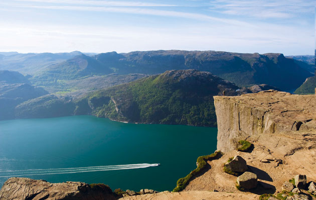
Further inshore you’ll see the humps of Rennesøy and Mosterøy, the two largest islands in the middle reaches, and beyond them the looming coastal mountains – an impressive backdrop for the inner sounds and penetrating fjords. Even in June the highest peaks still have traces of snow, an exotic sight from deck level.
Boats arriving from the south make the 40-mile coastal hop between Egersund and Tananger before rounding Tungenes point to enter Stavanger Bay.
 In gentle weather this is a fabulous run past a long coastal plain, with fertile green slopes falling to gleaming white beaches. This is prime Norwegian farmland and the sun glints on acres of glasshouses for tomatoes and fruit.
The first 25 miles from Egersund are exposed to the North Sea, but then a buoyed passage leads inside islands and skerries to Tananger Harbour (pictured above). The last short leg up to Tungenes is pretty well protected by Kvitsøy.