The crew of Egret are unsuccessful in their attempts to land at Pitcairn Island but they leave behind some mementos
28.8nm from Pitcairn Island (185nm from the entrance to the Gambier atoll)
Scott (YT) and Mary Flanders (MS) left Gibraltar on 16 September 2006, and we’ll be following their journey every step of the way, thanks to this unique online “blog”. For a complete list of all the couple’s blog entries click here
The crew of Egret are unsuccessful in their attempts to land at Pitcairn Island but they leave behind some mementos
Wednesday 14 May
Well, mis amigos, Pitcairn Island is unfortunately in our wake but first things first.
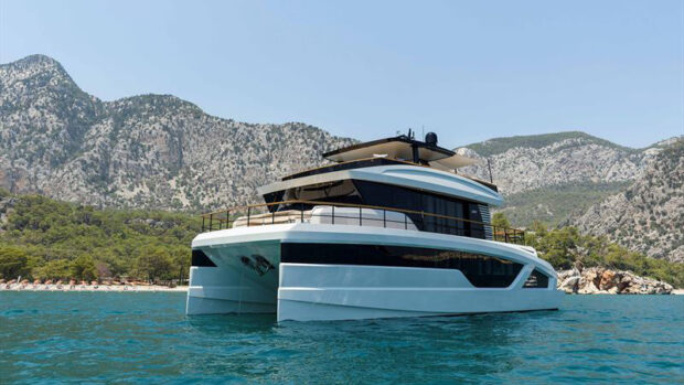
Pitcairn first appeared in the early morning gloom at 26.2nm as a small rounded hump in the distance. We were still making good time so in due course things became clearer as the sun rose and we got closer. Pitcairn has similarly high, rugged topography as Robinson Crusoe Island but it is mostly green with native trees, some quite tall and coconut trees.
Apparently Pitcairn is so remote and is so tricky to land at that the Europeans and South Americans didn’t strip the island of trees, land and sheep nor take the locals as slaves as they did on Robinson Crusoe Island and Easter Island. There are no beaches. The surf is continuous all around the island, whether wind driven or residual. Mary contacted Pitcairn Radio (ch16) two and a half hours out. The nice lady that answered in a Kiwi accent thanked us for the call and said she would have the mayor call back. The mayor, Jay Warren, one of the original mutineers, called as we closed in on Bounty Bay, the open roadstead anchorage off Adamstown, the only village. The mayor’s name is Jay Warren, one of the original mutineer’s kin. Half of the islanders have the surname Christian, the remaining are called Warren, Brown and Young. Of the 65 permanent residents of Pitcairn, 52 are direct descendents of the Bounty mutineers and their Tahitian wives.
As predicted by OMNI Bob the waves were rolling full force into the anchorage after the wind swung. Jay and his entourage, riding Honda 3 and 4 wheeler ATVs, rode down to the dock and decided it was too rough to launch their steel lifeboat. We asked if there was anything we could give them from our ship’s stores but he said no.
We desperately wanted to have some mail sent from Pitcairn so we could collect the extremely rare stamps for our friend Jenny Stern in Rhode Island, as well as Frank’s sweetie.
In the end we took a 2 and a half gallon water jug, triple zip-locked our goodies inside for postage with some money, some boat cards and a picture ofEgret. The whole package was duct-taped to the jug. The mayor guided us close to some near shore low rocks with surf pounding over the top to get the wave direction right. Frank was on the bow, Mary was freaking out, and at the last minute Frank threw the jug as far as he could in front of the boat and we turned and retreated offshore. Geesh. Ten minutes’ later Jay called and said they had recovered the jug and goodies and the postmaster was standing beside him. He said they think a boat will be by next month to collect mail, but he couldn’t be sure. It doesn’t matter. The Easter Island picture CD we sent Jenny in the package will be delivered much sooner by Frank when he returns to the States from Tahiti.
Sadly there’s not much more to tell, however we do have pictures we’ll show you as soon as we can. The complete set, Easter and Pitcairn, will arrive Stateside mid June with Frank. We would love to have gone ashore, particularly after seeing the island, but as Jay said “it is rare boaters’ land”.
So now we’re rockin along with the waves aft of the starboard beam in 20 knots of wind heading for Mangareva, the largest island in the Gambier Island group and our first French Polynesian (Society Islands) stop. About 285nm away. The Naiads are doing their deal, baits are out and all is well. We’ll see what tonight brings.
Thursday am
After daylight. It was a bumpy early evening with winds up to 30 knots from the NW. During the night the wind clocked to the SW and diminished to 15 knots or so. We are riding in confused swells but without any chop and we are comfortable. Last night the CCOM (coffeecarryometer) was bouncing around the 6-6.5 range. With 185nm to go there is no way we will be able to make landfall before dark, much less navigate through the coral reefs to the anchorage off Mangareva, Gambier Island Group. Mangareva is the only village in the atoll so we will keep up our present 1350RPM and present course.
There are two banks before the atoll entrance, one with a dangerous reef, so we’ll kill some late afternoon time trolling around the banks and then we’ll stand off perhaps 15-20 miles during the night for an entrance well after daybreak on Friday to be able to read the coral heads inside the atoll on the way to the anchorage. This is our first true South Pacific atoll with a surrounding coral reef, shallow water inside with numerous coral heads to navigate through. Our Swedish friends on a 37ft sloop,Lindisfarnehave told us there are markers although one is missing.
It is a beautiful day at sea. What will today bring? Ciao.
Picture 1. Approaching Pitcairn Island
Picture 2. Approaching Bounty Bay